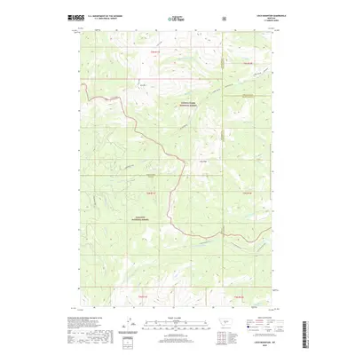
2020 Map of Loco Mountain
USGS Topo · Published 2020About this map
Lewis & Clark National Forest and Gallatin National Forest meet in this high-altitude landscape dominated by the peaks of the Crazy Mountains. This modern survey illustrates a complex hydrologic divide where the Shields River and its numerous tributaries, including Lebo Fork and Lodgepole Creek, drain the western slopes. To the east and north, the terrain gives way to the headwaters of the Big Elk and American Fork systems, including the Middle Fork Big Elk Creek and South Fork American Fork. Significant landmarks like Loco Mountain and Lebo Peak anchor the topography, while Elk Lake provides a rare high-mountain water body. The map also delineates several county boundaries, showing where Park, Meagher, Wheatland, and Sweet Grass counties converge amidst the steep drainage basins of Crow Creek and Blacktail Creek.
Find a feature on this map
41 named features on this map. Tap any name to fly to it.
Don’t see what you’re looking for? This feature index may not catch every label — zoom into the map to look around manually.
Map Details
Editions of this 2020 Loco Mountain Map
This is the sole edition of this map. No revisions or reprints were ever made.
Other maps of this area

1886 · Little Belt Mts.
USGS Topo · 1:250,000

1894 · Little Belt Mts.
USGS Topo · 1:250,000

1897 · Little Belt Mts.
USGS Topo · 1:250,000

1898 · Little Belt Mts.
USGS Topo · 1:250,000

1902 · Little Belt Mts.
USGS Topo · 1:250,000

1948 · White Sulphur Springs
USGS Topo · 1:250,000

1958 · White Sulphur Springs
USGS Topo · 1:250,000

1961 · White Sulphur Springs
USGS Topo · 1:250,000

1965 · White Sulphur Springs
USGS Topo · 1:250,000
1972 · Virginia Peak
USGS Topo · 1:24,000