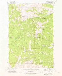
1972 Map of Loco Mountain
USGS Topo · Published 1976About this map
Loco Mountain and Lebo Peak anchor this high-altitude landscape within the Lewis and Clark National Forest and Gallatin National Forest. This 1970s survey captures a transition zone where the headwaters of the Shields River and numerous forks of the American Fork emerge from the steep topography. The map illustrates a wilderness-oriented economy and recreational landscape, defined by Pack Trails and Jeep Trails rather than established roads.
Find a feature on this map
29 named features on this map. Tap any name to fly to it.
Don’t see what you’re looking for? This feature index may not catch every label — zoom into the map to look around manually.
Map Details
Editions of this 1972 Loco Mountain Map
This is the sole edition of this map. No revisions or reprints were ever made.
Other maps of this area

1886 · Little Belt Mts.
USGS Topo · 1:250,000

1894 · Little Belt Mts.
USGS Topo · 1:250,000

1897 · Little Belt Mts.
USGS Topo · 1:250,000

1898 · Little Belt Mts.
USGS Topo · 1:250,000

1902 · Little Belt Mts.
USGS Topo · 1:250,000

1948 · White Sulphur Springs
USGS Topo · 1:250,000

1958 · White Sulphur Springs
USGS Topo · 1:250,000

1961 · White Sulphur Springs
USGS Topo · 1:250,000

1965 · White Sulphur Springs
USGS Topo · 1:250,000
1972 · Virginia Peak
USGS Topo · 1:24,000