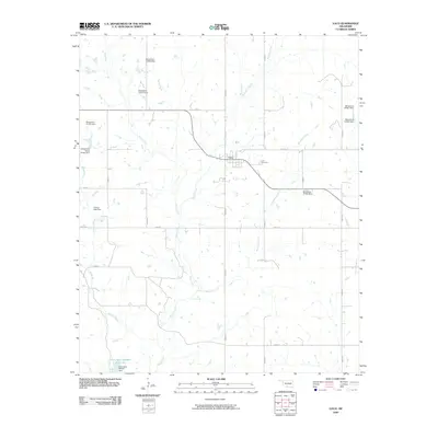
2009 Map of Loco
USGS Topo · Published 2009About this map
Loco sits as the central settlement in this Southern Oklahoma landscape, where the town’s residential grid and the Loco Cemetery serve as primary landmarks for local history and genealogy. The terrain is defined by an intricate network of waterways, including Mountain Creek, Negro Creek, and Pine Creek, which flow through a region heavily modified by water management projects. Numerous numbered dams, such as those forming Oknoname 067007 Reservoir and Conoco Lake Dam, illustrate the infrastructure required for water retention in the Red River basin. The map reveals a strictly organized section-line road system, with routes like e1850 RD and n2980 RD providing access to the dispersed homesteads and agricultural plots that surround the village. This survey documents the intersection of rural residential life and the managed hydrology of Stephens County during the early 21st century.
Find a feature on this map
29 named features on this map. Tap any name to fly to it.
Don’t see what you’re looking for? This feature index may not catch every label — zoom into the map to look around manually.
Map Details
Editions of this 2009 Loco Map
This is the sole edition of this map. No revisions or reprints were ever made.
Other maps of this area

1901 · Addington
USGS Topo · 1:125,000

1957 · Ardmore
USGS Topo · 1:250,000

1962 · Ryan
USGS Topo · 1:62,500

1963 · Ardmore
USGS Topo · 1:250,000

1963 · Harrisburg
USGS Topo · 1:24,000

1964 · Comanche SE
USGS Topo · 1:24,000

1974 · Ringling NW
USGS Topo · 1:24,000

1974 · Loco
USGS Topo · 1:24,000
1974 · Ratliff City
USGS Topo · 1:24,000
1974 · Cottonwood Creek
USGS Topo · 1:24,000