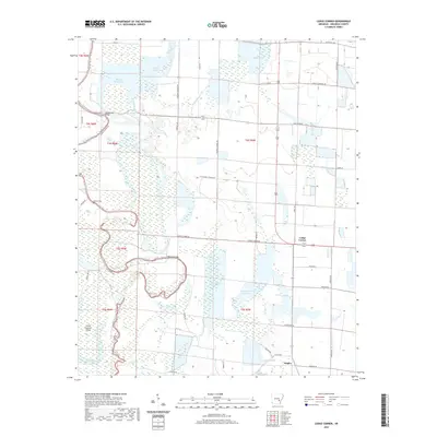
2020 Map of Lodge Corner
USGS Topo · Published 2020About this map
Lodge Corner and the small settlement of Hagler serve as the primary landmarks in this low-lying region of Arkansas County. The landscape is defined by an intricate network of waterways and managed water storage, including Wilson Reservoir, Hamptons Reservoir, and the winding course of Bayou Meto. This area exhibits a distinct agricultural and hydraulic character, where reservoirs and canals integrate with natural features like King Bayou and Kaney Bayou. Significant local landmarks include Youngblood Bridge and Benson Bridge, which facilitate transport across the bayou system. Genealogists will find the location of Bayless Cem notable, providing a point of reference for families rooted in this rural drainage basin. The map illustrates a modern era of land management where traditional natural terrain, such as Grand Cypress Island, exists alongside engineered water systems.
Find a feature on this map
46 named features on this map. Tap any name to fly to it.
Don’t see what you’re looking for? This feature index may not catch every label — zoom into the map to look around manually.
Map Details
Editions of this 2020 Lodge Corner Map
This is the sole edition of this map. No revisions or reprints were ever made.
Other maps of this area

1935 · Varner
USGS Topo · 1:62,500

1935 · Gillett
USGS Topo · 1:62,500

1941 · De Witt
USGS Topo · 1:62,500

1941 · Goldman
USGS Topo · 1:62,500

1948 · Helena
USGS Topo · 1:250,000

1950 · Helena
USGS Topo · 1:250,000

1954 · De Witt
USGS Topo · 1:62,500

1955 · Helena
USGS Topo · 1:250,000

1959 · Helena
USGS Topo · 1:250,000

1960 · Helena
USGS Topo · 1:250,000