
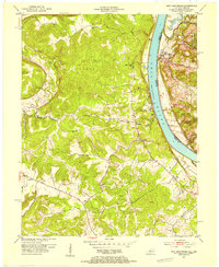
1947 Map of Lodiburg
USGS Topo · Published 1947About this map
Union Star and Lodiburg anchor this 1947 study of Breckinridge County, which captures a landscape of deeply incised valleys and winding ridgeline roads. The map highlights the localized settlement patterns of the late 1940s, with small rural nodes like Sample, Helm, and Mystic connected by improved and unimproved dirt roads. Waterways like Sinking Creek and Yellowbank Creek define the drainage of this dissected plateau, while landmarks such as the Pleasant Valley School provide specific points of interest for those researching local family history. The presence of multiple Cem (cemetery) markings near Ammon and Frymire further serves genealogists tracing early Kentucky residents. This survey, compiled from 1931 data and updated with 1946 aerial photography by the U.S. Army Air Force, reflects the transition from pre-war rural life to the post-war era, documenting the precise location of homesteads and small-scale community centers before modern development altered the rural character.
Find a feature on this map
21 named features on this map. Tap any name to fly to it.
Don’t see what you’re looking for? This feature index may not catch every label — zoom into the map to look around manually.
Map Details
Editions of this 1947 Lodiburg Map
This is the sole edition of this map. No revisions or reprints were ever made.
Other maps of this area

1928 · Hardinsburg
USGS Topo · 1:48,000

1931 · Hardinsburg
USGS Topo · 1:62,500

1934 · Cannelton
USGS Topo · 1:62,500

1947 · Irvington
USGS Topo · 1:24,000

1947 · Hardinsburg
USGS Topo · 1:24,000

1947 · Garfield
USGS Topo · 1:24,000

1947 · Hardinsburg
USGS Topo · 1:62,500
1950 · New Amsterdam
USGS Topo · 1:24,000

1950 · Alton
USGS Topo · 1:62,500

1950 · Alton
USGS Topo · 1:24,000