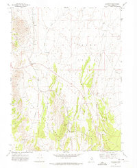
1971 Map of Lofgreen
USGS Topo · Published 1974About this map
Lofgreen serves as a central point of reference in this arid landscape, situated where the Union Pacific line cuts through the broad expanse of Rush Valley. The rail corridor is flanked by essential water infrastructure like the Water Tank, Cummings Well, and Scranton Well, reflecting the critical importance of reliable water sources for both steam-era transit and local ranching. To the west, the Wasatch National Forest borders the valley floor, where the terrain begins its ascent into the Vernon Hills and the sheltered pocket of Sharpes Valley. The presence of numerous Quarries, Borrow Pits, and a Gravel Pit indicates a landscape shaped by mineral extraction and road building. Seasonal drainage patterns are clearly defined by Sabie Creek and Boulter Creek, which channel runoff from the surrounding uplands toward the valley basin.
Find a feature on this map
20 named features on this map. Tap any name to fly to it.
Don’t see what you’re looking for? This feature index may not catch every label — zoom into the map to look around manually.
Map Details
Editions of this 1971 Lofgreen Map
This is the sole edition of this map. No revisions or reprints were ever made.
Other maps of this area

1885 · Sevier Desert
USGS Topo · 1:250,000

1885 · Tooele Valley
USGS Topo · 1:250,000

1947 · Fivemile Pass
USGS Topo · 1:62,500

1947 · Boulter Peak
USGS Topo · 1:24,000

1949 · Fivemile Pass
USGS Topo · 1:24,000

1953 · Tooele
USGS Topo · 1:250,000

1953 · Delta
USGS Topo · 1:250,000

1954 · Tintic Junction
USGS Topo · 1:24,000

1955 · Tooele
USGS Topo · 1:250,000

1958 · Delta
USGS Topo · 1:250,000