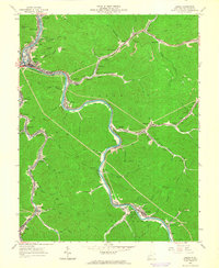
1963 Map of Logan
USGS Topo · Published 1964About this map
The Guyandotte River winds through the heart of the southern West Virginia coalfields in this early 1960s study, where industrial infrastructure and narrow valley settlements follow the water. The Chesapeake and Ohio railroad tracks parallel the river's bend, servicing a dense corridor of company towns and coal camps including Omar, Switzer, and Dehue. The topography is dominated by steep ridges like Rattlesnake Knob, leaving little room for development except along the narrow floodplains and hollows like Dingess Run and Ethel Hollow.
Find a feature on this map
77 named features on this map. Tap any name to fly to it.
Don’t see what you’re looking for? This feature index may not catch every label — zoom into the map to look around manually.
Map Details
Editions of this 1963 Logan Map
4 editions found
Other maps of this area

1887 · Warfield
USGS Topo · 1:125,000

1891 · Oceana
USGS Topo · 1:125,000

1891 · Warfield
USGS Topo · 1:125,000

1893 · Oceana
USGS Topo · 1:125,000

1898 · Oceana
USGS Topo · 1:125,000

1909 · Matewan
USGS Topo · 1:48,000

1909 · Gilbert
USGS Topo · 1:48,000

1910 · Holden
USGS Topo · 1:48,000

1912 · Gilbert
USGS Topo · 1:62,500

1912 · Holden
USGS Topo · 1:62,500