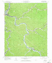
1963 Map of Logan
USGS Topo · Published 1973About this map
The Guyandotte River carves a winding path through this coal-country landscape, serving as the primary corridor for both the Chesapeake and Ohio railroad and a dense network of settlements including Logan, Stollings, and McConnell. This 1963 field-checked survey reveals the industrial and community character of the era, where narrow hollows are filled with mining operations and small company towns. Names like Dog Patch, Monaville, and Ethel are tucked into the steep valleys, often centered around local landmarks such as Sunbeam Chapel or the Hatfield Sch. The presence of several mine dumps and extensive strip mines near Freeze Fork and Mudlick Br underscores the extractive economy that shaped the topography. Higher elevations like Rattlesnake Knob overlook a valley increasingly connected by modern infrastructure, including the McDonald Airport and multiple radio towers like Radio Tower (WLOG).
Find a feature on this map
90 named features on this map. Tap any name to fly to it.
Don’t see what you’re looking for? This feature index may not catch every label — zoom into the map to look around manually.
Map Details
Editions of this 1963 Logan Map
4 editions found
Other maps of this area

1887 · Warfield
USGS Topo · 1:125,000

1891 · Oceana
USGS Topo · 1:125,000

1891 · Warfield
USGS Topo · 1:125,000

1893 · Oceana
USGS Topo · 1:125,000

1898 · Oceana
USGS Topo · 1:125,000

1909 · Matewan
USGS Topo · 1:48,000

1909 · Gilbert
USGS Topo · 1:48,000

1910 · Holden
USGS Topo · 1:48,000

1912 · Gilbert
USGS Topo · 1:62,500

1912 · Holden
USGS Topo · 1:62,500