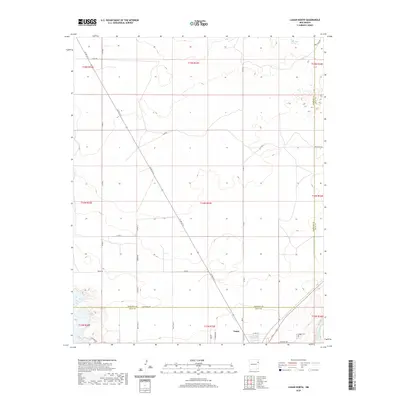
2020 Map of Logan North
USGS Topo · Published 2020About this map
Logan and its surrounding northern plains sit along the boundary of Harding and Quay counties, where the landscape is defined by a rigorous grid of ranch roads and township lines. The settlement at the southern edge of the sheet provides a focal point for the region, anchored by the Logan Cem located just off Cemetery Rd. The topography is marked by the winding course of the Canadian River in the southeast corner, contrasting with the high, dry plateaus that characterize much of the quadrangle.
Find a feature on this map
38 named features on this map. Tap any name to fly to it.
Don’t see what you’re looking for? This feature index may not catch every label — zoom into the map to look around manually.
Map Details
Editions of this 2020 Logan North Map
This is the sole edition of this map. No revisions or reprints were ever made.
Other maps of this area

1930 · Tucumcari
USGS Topo · 1:125,000

1954 · Tucumcari
USGS Topo · 1:250,000

1958 · Tucumcari
USGS Topo · 1:250,000

1962 · Logan
USGS Topo · 1:62,500

1966 · Lockney
USGS Topo · 1:24,000

1966 · Mc Carty Ranch
USGS Topo · 1:24,000

1968 · Hudson
USGS Topo · 1:24,000

1968 · Montesito Creek
USGS Topo · 1:24,000
1969 · Fuentes Ranch
USGS Topo · 1:24,000
1989 · Tuscocoillo Canyon
USGS Topo · 1:24,000