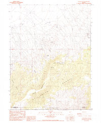
1990 Map of Logan Peak
USGS Topo · Published 1990About this map
Logan Peak and the high ridges of the Stillwater Range dominate this 1990 provisional study, marking the rugged boundary between Pershing and Churchill counties. The landscape is defined by its arid-land resource management, where water sources like Logan Spring, Kitten Springs, and Mustang Spring dictate the patterns of human activity. The map reveals a history of range life and extraction, documented through the Fencemaker Camp (Corral), Boyer Ranch, and several Borrow Pits and prospects.
Find a feature on this map
27 named features on this map. Tap any name to fly to it.
Don’t see what you’re looking for? This feature index may not catch every label — zoom into the map to look around manually.
Map Details
Editions of this 1990 Logan Peak Map
This is the sole edition of this map. No revisions or reprints were ever made.
Other maps of this area

1908 · Carson Sink
USGS Topo · 1:250,000

1910 · Carson Sink
USGS Topo · 1:250,000

1931 · Lovelock
USGS Topo · 1:250,000

1932 · Sonoma Range
USGS Topo · 1:250,000

1935 · Lovelock
USGS Topo · 1:250,000

1939 · Sonoma Range
USGS Topo · 1:250,000

1954 · Buffalo Mtn
USGS Topo · 1:62,500

1955 · Millett
USGS Topo · 1:250,000

1955 · Lovelock
USGS Topo · 1:250,000

1955 · Winnemucca
USGS Topo · 1:250,000