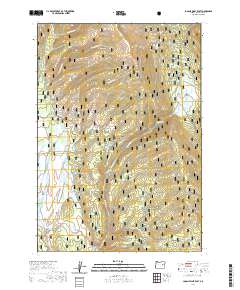
2020 Map of Logan Valley East
USGS Topo · Published 2020About this map
Logan Valley occupies the southwestern portion of this map, characterized by a series of drainage networks that define the landscape within the Malheur National Forest. This high-elevation terrain is shaped by numerous seasonal and year-round water sources, including the protected Malheur Wild and Scenic River which cuts through the southern reaches. The hydrology of the area is particularly complex, with features like Wickiuip Spring and Conroy Spring feeding into named tributaries such as Wickiuip Cr and Conroy Cr. North of the valley floor, the elevation rises toward Corral Basin and Keystone Gulch, while Summit Prairie marks a distinctive open space in the northeast. The distribution of these water sources and clearings reflects the traditional land use patterns of this part of Grant County, where mountain meadows and springs have historically supported seasonal grazing and timber management.
Find a feature on this map
26 named features on this map. Tap any name to fly to it.
Don’t see what you’re looking for? This feature index may not catch every label — zoom into the map to look around manually.
Map Details
Editions of this 2020 Logan Valley East Map
This is the sole edition of this map. No revisions or reprints were ever made.
Other maps of this area

1908 · Ironside Mountain
USGS Topo · 1:125,000

1955 · Canyon City
USGS Topo · 1:250,000

1959 · Canyon City
USGS Topo · 1:250,000

1959 · Prairie City
USGS Topo · 1:62,500

1961 · Logan Valley
USGS Topo · 1:62,500

1970 · Flag Prairie
USGS Topo · 1:62,500
1972 · Little Baldy Mnt.
USGS Topo · 1:24,000

1978 · John Day
USGS Topo · 1:100,000
1988 · Logan Valley East
USGS Topo · 1:24,000
1988 · Magpie Table
USGS Topo · 1:24,000