
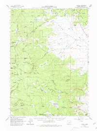
1961 Map of Logdell
USGS Topo · Published 1963About this map
The Silvies River meanders through the high mountain valleys of the Malheur National Forest in this early 1960s Oregon survey. Settled points like Logdell and Jenkins sit at the transition between the open meadows of Bear Valley and the heavily timbered slopes of the Blue Mountains. The map documents the infrastructure of forest management and early recreation, from the Bear Valley Guard Sta and an Airstrip to remote sites like Lost Cabin and Elkhorn Cow Camp. The landscape is defined by its complex drainage network, where names like Cheatem Holler Camp and Myrtle Park Meadows reflect the local history of ranching and timber work. Prominent landmarks such as Rail Creek Butte and Sand Mountain provide orientation across a terrain crisscrossed by jeep trails and creeks including Scotty Creek and Jenkins Creek.
Find a feature on this map
82 named features on this map. Tap any name to fly to it.
Don’t see what you’re looking for? This feature index may not catch every label — zoom into the map to look around manually.
Map Details
Editions of this 1961 Logdell Map
2 editions found
Other maps of this area

1940 · Mount Vernon
USGS Topo · 1:62,500

1940 · Aldrich Mtn.
USGS Topo · 1:62,500

1940 · John Day
USGS Topo · 1:62,500

1943 · Aldrich Mtn.
USGS Topo · 1:62,500

1943 · John Day
USGS Topo · 1:62,500

1943 · Mount Vernon
USGS Topo · 1:62,500

1955 · Burns
USGS Topo · 1:250,000

1955 · Canyon City
USGS Topo · 1:250,000

1958 · Burns
USGS Topo · 1:250,000

1959 · Burns
USGS Topo · 1:250,000