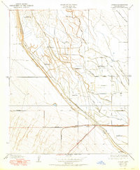
1950 Map of Lokern
USGS Topo · Published 1950About this map
Indian Burial Mounds and individual Indian Burial Mound sites are scattered throughout this landscape, indicating a significant indigenous history long before the arrival of modern agriculture. The terrain is defined by a complex network of man-made waterways designed to manage the arid environment, including the Main Drainage Canal, East Side Canal, and the School House Ditch. These irrigation features run parallel to the Buena Vista Slough, which dominates the central diagonal of the sheet.
Find a feature on this map
17 named features on this map. Tap any name to fly to it.
Don’t see what you’re looking for? This feature index may not catch every label — zoom into the map to look around manually.
Map Details
Editions of this 1950 Lokern Map
This is the sole edition of this map. No revisions or reprints were ever made.
Other maps of this area

1910 · Buena Vista Lake
USGS Topo · 1:125,000

1912 · McKittrick
USGS Topo · 1:125,000

1912 · Buena Vista Lake
USGS Topo · 1:125,000

1914 · Lost Hills
USGS Topo · 1:125,000

1927 · Semitropic
USGS Topo · 1:31,680

1930 · Leonards
USGS Topo · 1:31,680

1931 · Lokern
USGS Topo · 1:31,680

1931 · Goose Lake
USGS Topo · 1:31,680

1932 · West Elk Hills
USGS Topo · 1:31,680

1932 · East Elk Hills
USGS Topo · 1:31,680