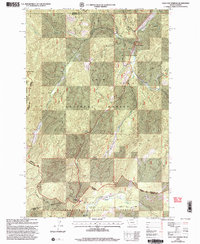
1999 Map of Lolo Hot Springs
USGS Topo · Published 2003About this map
Lolo Hot Springs serves as the focal point for this Bitterroot mountain landscape, where historical recreation and timber access define the terrain. The map documents the high-altitude divide between Lolo National Forest and Clearwater National Forest, tracking the critical state line boundary between Montana and Idaho. The presence of Packer Meadows and the Lolo Pass Winter Sports Area Visitor Center indicates the area's development for backcountry recreation at the close of the 20th century.
Find a feature on this map
35 named features on this map. Tap any name to fly to it.
Don’t see what you’re looking for? This feature index may not catch every label — zoom into the map to look around manually.
Map Details
Editions of this 1999 Lolo Hot Springs Map
This is the sole edition of this map. No revisions or reprints were ever made.
Other maps of this area

1911 · Lolo
USGS Topo · 1:250,000

1912 · Missoula
USGS Topo · 1:125,000

1913 · Lolo
USGS Topo · 1:250,000

1956 · Hamilton
USGS Topo · 1:250,000

1959 · Hamilton
USGS Topo · 1:250,000

1960 · Hamilton
USGS Topo · 1:250,000

1964 · Hamilton
USGS Topo · 1:250,000

1964 · Lolo Hot Springs
USGS Topo · 1:24,000

1964 · Garden Point
USGS Topo · 1:24,000

1964 · West Fork Butte
USGS Topo · 1:24,000