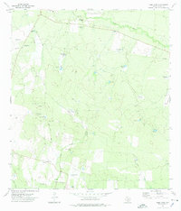
1972 Map of Loma Vista
USGS Topo · Published 1975About this map
Loma Vista and its surrounding ranchlands are documented here during the early 1970s, a landscape defined by an intricate network of water management features and cattle operations. The tiny settlement, situated along Loma Vista Road, is anchored by the Loma Vista Cem and overlooks the nearby Loma Vista Hill. The terrain is characterized by the meandering path of the Leona River to the north and numerous family-named stock ponds such as Old Zachman Tank, Tequache Tank, and Carmichael Tank. These "tanks" reveal the necessity of water storage in this semi-arid region of Zavala County. Traces of human industry are seen in scattered Drill Holes and a Pipeline, while the presence of the White Cotton Ranch highlights the area's continued reliance on large-scale pastoral agriculture.
Find a feature on this map
31 named features on this map. Tap any name to fly to it.
Don’t see what you’re looking for? This feature index may not catch every label — zoom into the map to look around manually.
Map Details
Editions of this 1972 Loma Vista Map
This is the sole edition of this map. No revisions or reprints were ever made.
Other maps of this area

1939 · Big Wells
USGS Topo · 1:62,500

1942 · Divot
USGS Topo · 1:62,500

1953 · Crystal City
USGS Topo · 1:250,000

1955 · Crystal City
USGS Topo · 1:250,000

1956 · Woodward
USGS Topo · 1:62,500

1956 · Divot
USGS Topo · 1:62,500

1957 · Batesville
USGS Topo · 1:62,500

1961 · Crystal City
USGS Topo · 1:250,000

1968 · Crystal City
USGS Topo · 1:250,000
1972 · Batesville
USGS Topo · 1:24,000