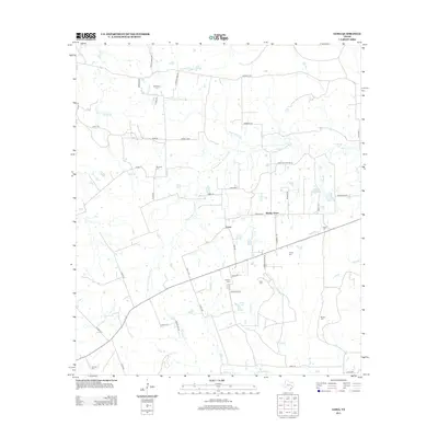
2013 Map of Loma
USGS Topo · Published 2013About this map
The W Fork San Jacinto River winds through the heart of this East Texas landscape, defining a terrain shaped by numerous tributary creeks and seasonal branches. Local activity centers around the settlement of Loma and the nearby community of Wesley Grove, where a network of county roads like Loma Rd and Morgan Rd connects family homesteads. The map is particularly notable for its density of small burial grounds, providing a significant resource for genealogical research. Named sites such as McCowan Cem, Mustang Cem, Foster Cem, and Red Top Cem are scattered throughout the countryside, often tucked near watercourses like Salty Cr or Neely Spring Br. While larger water bodies like Duke Lake and Morgan Lake are present, the overall pattern of the landscape remains defined by the winding paths of Clear Br, Gum Br, and Sulphur Cr.
Find a feature on this map
61 named features on this map. Tap any name to fly to it.
Don’t see what you’re looking for? This feature index may not catch every label — zoom into the map to look around manually.
Map Details
Editions of this 2013 Loma Map
This is the sole edition of this map. No revisions or reprints were ever made.
Other maps of this area

1954 · Beaumont
USGS Topo · 1:250,000

1957 · Beaumont
USGS Topo · 1:250,000

1959 · San Jacinto
USGS Topo · 1:24,000

1961 · Singleton
USGS Topo · 1:24,000

1962 · Richards
USGS Topo · 1:24,000
1962 · Roans Prairie
USGS Topo · 1:24,000

1962 · Galilee
USGS Topo · 1:24,000

1963 · Bedias
USGS Topo · 1:24,000

1963 · Steep Branch
USGS Topo · 1:24,000

1963 · Crabbs Prairie
USGS Topo · 1:24,000