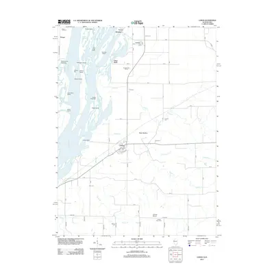
2012 Map of Lomax
USGS Topo · Published 2012About this map
The Mississippi River carves a complex network of channels and islands through this landscape, defining the borderland between Illinois and Iowa. Large river features like Burlington Island and Twomile Island dominate the western portion of the sheet, where complex sloughs such as Craigel Slough and Shokokon Slough indicate a dynamic riparian environment. On the Illinois side, the terrain shifts from the lowland river bottoms of Yellow Banks and Honey Creek Bar to a structured grid of agricultural lands and small settlements. The village of Lomax serves as a central hub, while smaller locales like Carman and Iowa Junction are scattered through the north and east. This era of the landscape is marked by numerous family and community burial grounds, including the Talbert Family Cem and Gittings Mound Cem, providing significant points of interest for genealogical research. Further inland, Gittings Mound rises as a distinct landmark overlooking the drainage of Weaver Br and Dugout Cr.
Find a feature on this map
66 named features on this map. Tap any name to fly to it.
Don’t see what you’re looking for? This feature index may not catch every label — zoom into the map to look around manually.
Map Details
Editions of this 2012 Lomax Map
This is the sole edition of this map. No revisions or reprints were ever made.
Other maps of this area

1918 · La Harpe
USGS Topo · 1:62,500

1932 · Lomax
USGS Topo · 1:62,500

1934 · Oquawka
USGS Topo · 1:48,000

1934 · Burlington
USGS Topo · 1:48,000

1937 · Lomax
USGS Topo · 1:62,500

1940 · Oquawka
USGS Topo · 1:62,500

1940 · Burlington
USGS Topo · 1:62,500

1958 · Burlington
USGS Topo · 1:250,000

1961 · Burlington
USGS Topo · 1:250,000

1963 · Burlington
USGS Topo · 1:250,000