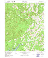
1979 Map of London SW
USGS Topo · Published 1980About this map
Daniel Boone National Forest covers the majority of this Kentucky landscape, characterized by the winding drainage of Cane Creek and the deep waters of Laurel River Lake in the southwest. The terrain is marked by both natural landmarks like the Natural Arch and industrial signatures of the late 20th century, including several Strip Mine operations scattered along the ridges. For those researching local history, the map preserves the locations of rural institutions such as the Baldrock School and the Baldrock Lookout Tower, alongside numerous country sanctuaries like New Hope Ch, Moores Chapel, and Locust Grove Ch. The settlement patterns around Keavy and Maple Grove reveal a community deeply connected to the ridgelines and the many cemeteries—including Bunch Cem and Pine Creek Cem—that serve as enduring links to the area's family lineages.
Find a feature on this map
63 named features on this map. Tap any name to fly to it.
Don’t see what you’re looking for? This feature index may not catch every label — zoom into the map to look around manually.
Map Details
Editions of this 1979 London SW Map
This is the sole edition of this map. No revisions or reprints were ever made.
Other maps of this area

1890 · Williamsburg
USGS Topo · 1:125,000

1893 · London
USGS Topo · 1:125,000

1894 · Williamsburg
USGS Topo · 1:125,000

1897 · London
USGS Topo · 1:125,000

1952 · Corbin
USGS Topo · 1:24,000

1952 · Lily
USGS Topo · 1:24,000

1952 · London SW
USGS Topo · 1:24,000

1952 · Vox
USGS Topo · 1:24,000

1952 · Billows
USGS Topo · 1:24,000

1952 · Ano
USGS Topo · 1:24,000