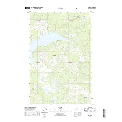
2020 Map of Lone Lake
USGS Topo · Published 2020About this map
Flathead National Forest land dominates this section of the Salish Mountains, where the 2020 landscape is defined by the high-elevation basin of Ashley Lake. The terrain is deeply textured by glacial and fluvial drainage patterns, notably McMannamy Draw in the north and Dower Draw to the south. Modern forest management and recreation are evident through the network of access routes, including Hodge Creek Rd and the Ashley Lake Trl. Smaller alpine bodies like Lone Lake and Lake Monroe sit at higher contours below Boorman Peak, illustrating the watershed for Ashley Cr and Boorman Cr. This map provides a detailed view of the contemporary forest boundary and the specific names attached to the ridges and valleys of this Montana backcountry.
Find a feature on this map
34 named features on this map. Tap any name to fly to it.
Don’t see what you’re looking for? This feature index may not catch every label — zoom into the map to look around manually.
Map Details
Editions of this 2020 Lone Lake Map
This is the sole edition of this map. No revisions or reprints were ever made.
Other maps of this area

1943 · Kalispell
USGS Topo · 1:125,000

1957 · Kalispell
USGS Topo · 1:250,000

1960 · Kalispell
USGS Topo · 1:250,000

1961 · Kalispell
USGS Topo · 1:250,000

1962 · Kila
USGS Topo · 1:24,000

1962 · Blue Grass Ridge
USGS Topo · 1:24,000

1962 · Lost Creek Divide
USGS Topo · 1:24,000

1962 · Ashley Mountain
USGS Topo · 1:24,000

1962 · Rhodes
USGS Topo · 1:24,000
1964 · Lone Lake
USGS Topo · 1:24,000