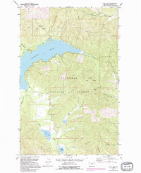
1991 Map of Lone Lake
USGS Topo · Published 1995About this map
Stillwater State Forest and the Flathead National Forest dominate this landscape, which is defined by high-elevation water bodies and drainage systems. Central to the map is the expansive Ashley Lake, which serves as a focal point for the region's recreational and natural geography, including a designated campground on its western shore near Rand Creek. To the south, smaller water bodies like Lone Lake and Lake Monroe are connected by the winding Ashley Creek, illustrating the complex hydrology of the mountainous Montana terrain.
Find a feature on this map
21 named features on this map. Tap any name to fly to it.
Don’t see what you’re looking for? This feature index may not catch every label — zoom into the map to look around manually.
Map Details
Editions of this 1991 Lone Lake Map
This is the sole edition of this map. No revisions or reprints were ever made.
Other maps of this area

1943 · Kalispell
USGS Topo · 1:125,000

1957 · Kalispell
USGS Topo · 1:250,000

1960 · Kalispell
USGS Topo · 1:250,000

1961 · Kalispell
USGS Topo · 1:250,000

1962 · Kila
USGS Topo · 1:24,000

1962 · Blue Grass Ridge
USGS Topo · 1:24,000

1962 · Lost Creek Divide
USGS Topo · 1:24,000

1962 · Ashley Mountain
USGS Topo · 1:24,000

1962 · Rhodes
USGS Topo · 1:24,000
1964 · Lone Lake
USGS Topo · 1:24,000