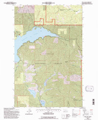
1994 Map of Lone Lake
USGS Topo · Published 1997About this map
The Flathead National Forest defines this mountain landscape, which was updated by the U.S. Forest Service in the mid-1990s using aerial data from 1990. The sheet is dominated by the sprawling expanse of Ashley Lake in the northern half, while the central and southern reaches are characterized by a series of high ridges and narrow drainages. Notable peaks like Boorman Peak provide context for the local topography, which feeds into a network of water bodies including Lone Lake and Lake Monroe. A Gravel Pit near the eastern margin hints at small-scale resource extraction within the forest boundaries. The map also meticulously traces several local draws and creeks such as McMannamy Draw and Boorman Creek, which have long served as natural corridors through the timbered terrain of Flathead County.
Find a feature on this map
16 named features on this map. Tap any name to fly to it.
Don’t see what you’re looking for? This feature index may not catch every label — zoom into the map to look around manually.
Map Details
Editions of this 1994 Lone Lake Map
This is the sole edition of this map. No revisions or reprints were ever made.
Other maps of this area

1943 · Kalispell
USGS Topo · 1:125,000

1957 · Kalispell
USGS Topo · 1:250,000

1960 · Kalispell
USGS Topo · 1:250,000

1961 · Kalispell
USGS Topo · 1:250,000

1962 · Kila
USGS Topo · 1:24,000

1962 · Blue Grass Ridge
USGS Topo · 1:24,000

1962 · Lost Creek Divide
USGS Topo · 1:24,000

1962 · Ashley Mountain
USGS Topo · 1:24,000

1962 · Rhodes
USGS Topo · 1:24,000
1964 · Lone Lake
USGS Topo · 1:24,000