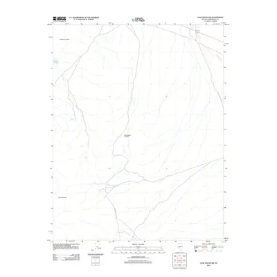
2012 Map of Lone Mountain
USGS Topo · Published 2012About this map
Big Smoky Valley dominates the northern expanse of this Esmeralda County landscape, illustrating a classic Great Basin drainage pattern where water features are rare and vital landmarks. The 2012 survey highlights the prominence of Lone Mountain in the southwest, a topographical anchor for the surrounding high desert. Vital water sources like Lobo Spring, Willow Spring, and the isolated Millers Pond suggest the historic importance of these locations for transit and local livestock in an otherwise arid environment. Evidence of human infrastructure is concentrated along Paymaster Canyon Rd and the routes threading through Springdale Canyon, which follow the natural contours of the desert floor and provide access to the interior mountain terrain. The presence of Lime Wash in the northeast further defines the seasonal hydrological character of this remote Nevada quadrangle.
Find a feature on this map
8 named features on this map. Tap any name to fly to it.
Don’t see what you’re looking for? This feature index may not catch every label — zoom into the map to look around manually.
Map Details
Editions of this 2012 Lone Mountain Map
This is the sole edition of this map. No revisions or reprints were ever made.
Other maps of this area

1898 · Silver Peak
USGS Topo · 1:125,000

1900 · Silver Peak
USGS Topo · 1:125,000

1907 · Tonopah
USGS Topo · 1:250,000

1908 · Lida
USGS Topo · 1:250,000

1908 · Tonopah
USGS Topo · 1:250,000

1913 · Lida
USGS Topo · 1:250,000

1945 · Goldfield
USGS Topo · 1:125,000

1954 · Goldfield
USGS Topo · 1:250,000

1955 · Goldfield
USGS Topo · 1:250,000

1956 · Tonopah
USGS Topo · 1:250,000