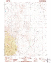
1987 Map of Lone Mountain
USGS Topo · Published 1987About this map
Lone Mountain rises as the dominant landform in this 1980s Esmeralda County landscape, where the terrain transitions from high peaks down into the broad Smokey Valley. Evidence of earlier transport and settlement is etched into the desert floor, most notably through the Old Railroad Grade and several clusters of Ruins found near the base of the mountain. The map reveals a reliance on isolated water sources such as Mikes Well, Lobo Spring, and Willow Spring, which likely supported the small-scale mining efforts indicated by various Prospects and a Borrow Pit scattered across the quadrangle. A small Cem (cemetery) located near the northern margin and the presence of Slime Wash further suggest the remnants of a once-active community or industrial camp tied to the arid geography of the Great Basin.
Find a feature on this map
18 named features on this map. Tap any name to fly to it.
Don’t see what you’re looking for? This feature index may not catch every label — zoom into the map to look around manually.
Map Details
Editions of this 1987 Lone Mountain Map
This is the sole edition of this map. No revisions or reprints were ever made.
Other maps of this area

1898 · Silver Peak
USGS Topo · 1:125,000

1900 · Silver Peak
USGS Topo · 1:125,000

1907 · Tonopah
USGS Topo · 1:250,000

1908 · Lida
USGS Topo · 1:250,000

1908 · Tonopah
USGS Topo · 1:250,000

1913 · Lida
USGS Topo · 1:250,000

1945 · Goldfield
USGS Topo · 1:125,000

1954 · Goldfield
USGS Topo · 1:250,000

1955 · Goldfield
USGS Topo · 1:250,000

1956 · Tonopah
USGS Topo · 1:250,000