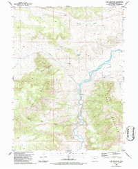
1986 Map of Lone Mountain
USGS Topo · Published 1986About this map
The Little Snake River carves a central path through this landscape, dividing the high elevations of Douglas Mountain to the west from Cross Mountain to the east. This 1986 survey illustrates a topography shaped by seasonal water movement, where drainages like East Boone Draw and Wild Cow Draw channel toward the river corridor. The presence of a Gaging Sta along the riverbank indicates the ongoing importance of hydrological monitoring in this arid Moffat County environment during the late 20th century. High points such as Lone Mountain and the sheltered Thompson Canyon overlook a terrain punctuated by isolated water sources, including Thompson Springs and several unnamed Springs. These water features were essential anchors for land use in a region defined by its extreme relief and riparian transition zones.
Find a feature on this map
13 named features on this map. Tap any name to fly to it.
Don’t see what you’re looking for? This feature index may not catch every label — zoom into the map to look around manually.
Map Details
Editions of this 1986 Lone Mountain Map
This is the sole edition of this map. No revisions or reprints were ever made.
Other maps of this area

1907 · Rangely
USGS Topo · 1:125,000

1907 · White River
USGS Topo · 1:125,000

1910 · White River
USGS Topo · 1:125,000

1910 · Rangely
USGS Topo · 1:125,000

1954 · Vernal
USGS Topo · 1:250,000

1958 · Vernal
USGS Topo · 1:250,000

1960 · Vernal
USGS Topo · 1:250,000

1960 · Elk Springs
USGS Topo · 1:62,500

1960 · Lone Mountain
USGS Topo · 1:62,500

1962 · Indian Water Canyon
USGS Topo · 1:24,000