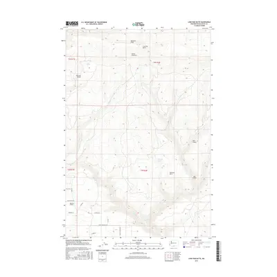
2017 Map of Lone Pine Butte
USGS Topo · Published 2017About this map
Simcoe Mountains dominate the high-elevation landscape of this Klickitat County quadrangle, where the terrain transitions through a series of ridges and deep canyons. Prominent landmarks such as Lone Pine Butte and Bickleton Ridge define the northern heights, while the southern reaches descend toward Munson Prairie. The mapping reveals a sparse but telling network of local roads that reflect long-standing land use, including Ownby Homestead Rd, Harbison Rd, and the curiously named Wanna B A Ranch Rd. Water is a critical and concentrated resource in this environment, marked by isolated points like Tumwater Corral Spring, Beeks Spring, and Bear Spring. Significant geological features such as Idlewood Canyon and Box Canyon emphasize the deeply incised drainage patterns of Quartz Cr and Rock Cr, illustrating the complex topography of the Washington interior.
Find a feature on this map
28 named features on this map. Tap any name to fly to it.
Don’t see what you’re looking for? This feature index may not catch every label — zoom into the map to look around manually.
Map Details
Editions of this 2017 Lone Pine Butte Map
This is the sole edition of this map. No revisions or reprints were ever made.
Other maps of this area

1910 · Zillah
USGS Topo · 1:125,000

1916 · Arlington
USGS Topo · 1:125,000

1937 · White Swan
USGS Topo · 1:125,000

1950 · Yakima
USGS Topo · 1:250,000

1953 · The Dalles
USGS Topo · 1:250,000

1956 · The Dalles
USGS Topo · 1:250,000

1957 · The Dalles
USGS Topo · 1:250,000

1957 · Satus Pass
USGS Topo · 1:62,500

1958 · Yakima
USGS Topo · 1:250,000

1961 · Yakima
USGS Topo · 1:250,000