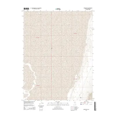
2014 Map of Lone Rock SE
USGS Topo · Published 2014About this map
Carson Sink dominates this desert landscape in Churchill County, representing a significant terminal drainage basin where the waters of the Carson River historically gathered and evaporated. The 2014 terrain is characterized by broad alkali flats and subtle topographic shifts, illustrating the stark hydrology of the Lahontan Basin. While largely defined by its prehistoric lake bed, the eastern edge of the map shows more varied relief near Mill Canyon, where the desert floor meets the rising slopes of the Stillwater Range. Human presence is sparse, marked primarily by the utility of E Co Rd as it skirts the foothills. The meticulous survey lines of the Public Land Survey System, including t23n r33e and t22n r32e, provide the primary structural framework for navigating this remote corner of Nevada.
Find a feature on this map
7 named features on this map. Tap any name to fly to it.
Don’t see what you’re looking for? This feature index may not catch every label — zoom into the map to look around manually.
Map Details
Editions of this 2014 Lone Rock SE Map
This is the sole edition of this map. No revisions or reprints were ever made.
Other maps of this area

1908 · Carson Sink
USGS Topo · 1:250,000

1910 · Carson Sink
USGS Topo · 1:250,000

1957 · Reno
USGS Topo · 1:250,000

1959 · Reno
USGS Topo · 1:250,000

1960 · Reno
USGS Topo · 1:250,000

1966 · Dixie Hot Springs
USGS Topo · 1:62,500
1969 · Lone Rock SW
USGS Topo · 1:24,000

1969 · Cox Canyon
USGS Topo · 1:24,000

1969 · Pintail Bay
USGS Topo · 1:24,000
1969 · Lone Rock
USGS Topo · 1:24,000