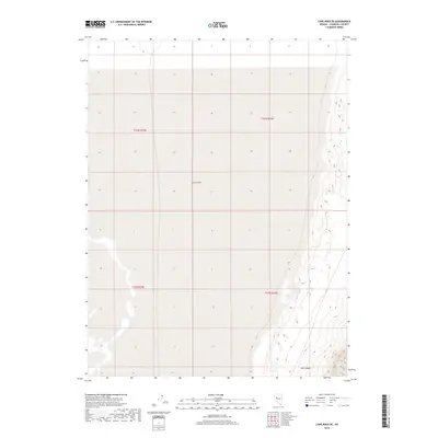
2018 Map of Lone Rock SE
USGS Topo · Published 2018About this map
Carson Sink dominates this interior portion of Churchill County, representing the terminus of the Carson River where it vanishes into the alkali flats. The landscape is defined by the vast, arid expanse of the sink, which transitions into the rising elevations of Mill Canyon on the eastern edge of the quadrangle. This 2018 survey provides a clear view of the Public Land Survey System grid across the desert, delineating the boundaries of T23N R32E, T23N R33E, T22N R32E, and T22N R33E. The lack of modern development or permanent settlements underscores the isolation of this corner of the Nevada Great Basin, where the shifting margins of the sink and the steep contours of the canyon floor remain the primary geographic features.
Find a feature on this map
6 named features on this map. Tap any name to fly to it.
Don’t see what you’re looking for? This feature index may not catch every label — zoom into the map to look around manually.
Map Details
Editions of this 2018 Lone Rock SE Map
This is the sole edition of this map. No revisions or reprints were ever made.
Other maps of this area

1908 · Carson Sink
USGS Topo · 1:250,000

1910 · Carson Sink
USGS Topo · 1:250,000

1957 · Reno
USGS Topo · 1:250,000

1959 · Reno
USGS Topo · 1:250,000

1960 · Reno
USGS Topo · 1:250,000

1966 · Dixie Hot Springs
USGS Topo · 1:62,500
1969 · Lone Rock SW
USGS Topo · 1:24,000

1969 · Cox Canyon
USGS Topo · 1:24,000

1969 · Pintail Bay
USGS Topo · 1:24,000
1969 · Lone Rock
USGS Topo · 1:24,000