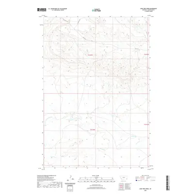
2020 Map of Lone Tree Creek
USGS Topo · Published 2020About this map
Lone Tree Cr and its neighboring drainages define the landscape of this Carter County corner, where the terrain transitions through open range and creek bottoms. This modern topographic study reveals a quiet corner of Montana organized by the Public Land Survey System, as seen in the grid of t4s r60e and t5s r60e. Local transportation relies on a network of unpaved routes, including Sheep Mountain Rd and Chimney Rock Rd, which follow the contours of the high ground between the watercourses. The drainage of Cottonwood Cr winds across the central portion of the sheet, illustrating the sparse but vital water resources in this part of the state. It is a portrait of a working landscape where geography is measured by township lines and the seasonal flow of Hackberry Cr.
Find a feature on this map
10 named features on this map. Tap any name to fly to it.
Don’t see what you’re looking for? This feature index may not catch every label — zoom into the map to look around manually.
Map Details
Editions of this 2020 Lone Tree Creek Map
This is the sole edition of this map. No revisions or reprints were ever made.
Other maps of this area

1954 · Ekalaka
USGS Topo · 1:250,000

1956 · Ekalaka
USGS Topo · 1:250,000

1958 · Ekalaka
USGS Topo · 1:250,000

1965 · Ekalaka
USGS Topo · 1:250,000

1980 · Prairie Dog Creek
USGS Topo · 1:24,000

1980 · Cactus Creek West
USGS Topo · 1:24,000

1980 · Finger Buttes East
USGS Topo · 1:24,000

1980 · Belltower Butte
USGS Topo · 1:24,000
1980 · School Section Creek
USGS Topo · 1:24,000
1980 · Capitol NW
USGS Topo · 1:24,000