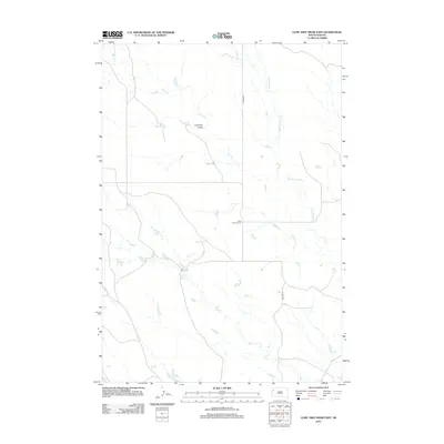
2012 Map of Lone Tree Draw East
USGS Topo · Published 2012About this map
Saint Anthony Cem sits as a solitary landmark within this expansive drainage landscape in Butte County. The terrain is defined by the branching networks of Sand Cr, Second Sand Cr, and Hay Cr, which carve seasonal paths across the high plains. This 2012 survey illustrates the sparse, rural infrastructure of the region, where travel is dictated by routes like Mason Rd and the path of Old Hwy 79. The namesake Lone Tree Draw highlights the importance of specific landmarks in an otherwise open environment. This map is particularly useful for those tracing family history related to the remote cemeteries of South Dakota or studying the hydrologic patterns of the northern plains before modern developments.
Find a feature on this map
7 named features on this map. Tap any name to fly to it.
Don’t see what you’re looking for? This feature index may not catch every label — zoom into the map to look around manually.
Map Details
Editions of this 2012 Lone Tree Draw East Map
This is the sole edition of this map. No revisions or reprints were ever made.
Other maps of this area

1935 · Hoover
USGS Topo · 1:125,000

1935 · Harding
USGS Topo · 1:125,000

1954 · Lemmon
USGS Topo · 1:250,000

1957 · Lemmon
USGS Topo · 1:250,000

1973 · Lone Tree Draw East
USGS Topo · 1:24,000

1973 · Lone Tree Draw West
USGS Topo · 1:24,000
1973 · Antelope Creek East
USGS Topo · 1:24,000

1973 · Redig
USGS Topo · 1:24,000
1973 · Haystack Butte
USGS Topo · 1:24,000
1977 · Hoover
USGS Topo · 1:24,000