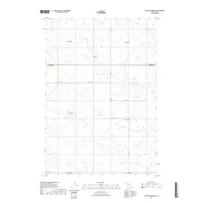
2017 Map of Lone Tree Draw East
USGS Topo · Published 2017About this map
Saint Anthony Cem marks a lonely cultural anchor in the northern reaches of Butte County, situated near the intersection of St Anthony's Rd and Sand Creek Rd. This high plains landscape is defined by the ephemeral drainage of Lone Tree Draw and the winding paths of Sand Cr and Second Sand Cr, which cut through the undulating terrain near the border with Harding County. The network of local routes, including Old State Hwy 79 and Mason Rd, traces the movement of ranching life across these vast townships. While contemporary in its mapping, the survey preserves the spatial relationships of historic cemeteries and road alignments that have served this sparsely populated region of South Dakota for generations, including the southern flow of Hay Cr toward the quadrangle boundary.
Find a feature on this map
16 named features on this map. Tap any name to fly to it.
Don’t see what you’re looking for? This feature index may not catch every label — zoom into the map to look around manually.
Map Details
Editions of this 2017 Lone Tree Draw East Map
This is the sole edition of this map. No revisions or reprints were ever made.
Other maps of this area

1935 · Hoover
USGS Topo · 1:125,000

1935 · Harding
USGS Topo · 1:125,000

1954 · Lemmon
USGS Topo · 1:250,000

1957 · Lemmon
USGS Topo · 1:250,000

1973 · Lone Tree Draw East
USGS Topo · 1:24,000

1973 · Lone Tree Draw West
USGS Topo · 1:24,000
1973 · Antelope Creek East
USGS Topo · 1:24,000

1973 · Redig
USGS Topo · 1:24,000
1973 · Haystack Butte
USGS Topo · 1:24,000
1977 · Hoover
USGS Topo · 1:24,000