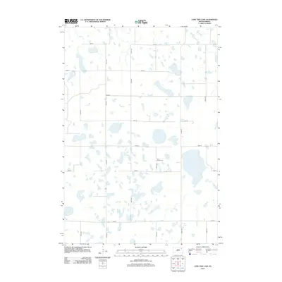
2012 Map of Lone Tree Lake
USGS Topo · Published 2012About this map
Saint Ansgaar Cem stands as a focal point for genealogical research in this rural portion of Clark County, surrounded by a complex network of glacial wetlands and prairie potholes. The landscape is defined by an orderly grid of local section roads, including 150th St and 420th Ave, which navigate a terrain densely pocketed with seasonal water bodies. In the southwest, the eponymous Lone Tree Lake is a prominent feature among the scattered basins, while the northern reaches are drained by the meandering course of Mud Cr. This 2012 survey illustrates the enduring agricultural character of the region, where the placement of small cemeteries like Saint Ansgaar remains one of the few named markers of the community's early settlement history.
Find a feature on this map
16 named features on this map. Tap any name to fly to it.
Don’t see what you’re looking for? This feature index may not catch every label — zoom into the map to look around manually.
Map Details
Editions of this 2012 Lone Tree Lake Map
This is the sole edition of this map. No revisions or reprints were ever made.
Other maps of this area

1953 · Milbank
USGS Topo · 1:250,000

1958 · Milbank
USGS Topo · 1:250,000

1958 · Andover SW
USGS Topo · 1:24,000
1958 · Crandall
USGS Topo · 1:24,000
1973 · Crocker SW
USGS Topo · 1:24,000

1973 · Lily
USGS Topo · 1:24,000

1973 · Bristol West
USGS Topo · 1:24,000

1973 · Bradley
USGS Topo · 1:24,000

1973 · Lone Tree Lake
USGS Topo · 1:24,000

1973 · Bristol East
USGS Topo · 1:24,000