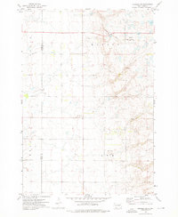
1973 Map of Crocker SW
USGS Topo · Published 1975About this map
The Chicago and North Western railway cuts across the northern section of this Dakota prairie landscape, marking the primary transportation artery for the rural townships of Olean, Warren, Turton, and Ash. This 1973 field-checked survey reveals a sparsely populated agricultural region defined by section lines and wide-open spaces. A local Townhall stands centrally in Warren Township, serving as a civic anchor for the surrounding farmsteads.
Find a feature on this map
10 named features on this map. Tap any name to fly to it.
Don’t see what you’re looking for? This feature index may not catch every label — zoom into the map to look around manually.
Map Details
Editions of this 1973 Crocker SW Map
This is the sole edition of this map. No revisions or reprints were ever made.
Other maps of this area

1894 · Conde
USGS Topo · 1:62,500

1895 · Byron
USGS Topo · 1:125,000

1895 · Aberdeen
USGS Topo · 1:125,000

1953 · Milbank
USGS Topo · 1:250,000

1953 · Huron
USGS Topo · 1:250,000

1953 · Watertown
USGS Topo · 1:250,000

1954 · Aberdeen
USGS Topo · 1:250,000

1954 · Huron
USGS Topo · 1:250,000

1956 · Aberdeen
USGS Topo · 1:250,000

1958 · Milbank
USGS Topo · 1:250,000