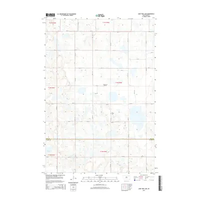
2015 Map of Lone Tree Lake
USGS Topo · Published 2015About this map
Coteau des Prairies defines the elevated landscape of this South Dakota region, where glacial activity left behind a complex network of wetlands and depressions. The map reveals a strictly regulated agrarian layout, with section lines and gravel roads like 150th St and 421st Ave framing the prairie. Historical footprints are preserved at the Saint Ansgaar Cem in the central portion of the quadrangle, serving as a landmark for local family researchers. The southern reaches are characterized by substantial water bodies, most notably Lone Tree Lake, while Mud Cr provides drainage in the north. This survey illustrates the persistence of the section-line road system in maintaining the region's agricultural continuity across the Day and Clark County line.
Find a feature on this map
26 named features on this map. Tap any name to fly to it.
Don’t see what you’re looking for? This feature index may not catch every label — zoom into the map to look around manually.
Map Details
Editions of this 2015 Lone Tree Lake Map
This is the sole edition of this map. No revisions or reprints were ever made.
Other maps of this area

1953 · Milbank
USGS Topo · 1:250,000

1958 · Milbank
USGS Topo · 1:250,000

1958 · Andover SW
USGS Topo · 1:24,000
1958 · Crandall
USGS Topo · 1:24,000
1973 · Crocker SW
USGS Topo · 1:24,000

1973 · Lily
USGS Topo · 1:24,000

1973 · Bristol West
USGS Topo · 1:24,000

1973 · Bradley
USGS Topo · 1:24,000

1973 · Lone Tree Lake
USGS Topo · 1:24,000

1973 · Bristol East
USGS Topo · 1:24,000