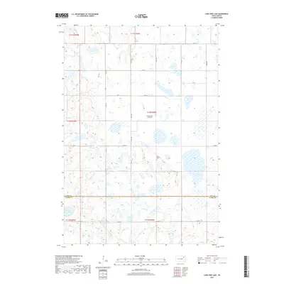
2017 Map of Lone Tree Lake
USGS Topo · Published 2017About this map
The high plateau of the Coteau des Prairies defines the geography of this rural landscape, which straddles the border between Day County and Clark County. The terrain is characterized by a dense pattern of prairie potholes and wetlands, typical of the glacial history of this region in eastern South Dakota. Lone Tree Lake sits in the southwestern corner, while Mud Cr drains the northwestern section. Human presence is primarily represented by a regular grid of section lines and secondary roads such as Co Rd 42 and 420th Ave. For genealogists and local historians, the Saint Ansgaar Cem stands as a notable landmark near the center of the sheet, providing a focal point for the early settlement history of this agricultural township.
Find a feature on this map
31 named features on this map. Tap any name to fly to it.
Don’t see what you’re looking for? This feature index may not catch every label — zoom into the map to look around manually.
Map Details
Editions of this 2017 Lone Tree Lake Map
This is the sole edition of this map. No revisions or reprints were ever made.
Other maps of this area

1953 · Milbank
USGS Topo · 1:250,000

1958 · Milbank
USGS Topo · 1:250,000

1958 · Andover SW
USGS Topo · 1:24,000
1958 · Crandall
USGS Topo · 1:24,000
1973 · Crocker SW
USGS Topo · 1:24,000

1973 · Lily
USGS Topo · 1:24,000

1973 · Bristol West
USGS Topo · 1:24,000

1973 · Bradley
USGS Topo · 1:24,000

1973 · Lone Tree Lake
USGS Topo · 1:24,000

1973 · Bristol East
USGS Topo · 1:24,000