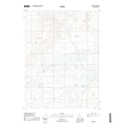
2017 Map of Lonetree
USGS Topo · Published 2017About this map
Lonetree and its surrounding high-desert landscape in Uinta County are defined by an intricate network of irrigation systems and grazing lands. The settlement sits near the confluence of several vital water management features, including the Grimsley Ditch, Luckey Ditch, and Stag Hollow Ditch, which redirect water from Henrys Fork to the arid terrain. To the north, Hickey Mtn and the Hickey Mountain Reservoir dominate the upland topography, while the Bald Range rises to the southeast. This 2017 survey documents the modern layout of rural infrastructure, from the Lonetree Cem to the local road network consisting of Co RD 294 and Co RD 295. The distribution of natural drainages like Beaver Cr and Poison Cr alongside man-made canals like the Cedar Basin Ditch illustrates the long-standing ranching and agricultural priorities of this corner of Wyoming.
Find a feature on this map
63 named features on this map. Tap any name to fly to it.
Don’t see what you’re looking for? This feature index may not catch every label — zoom into the map to look around manually.
Map Details
Editions of this 2017 Lonetree Map
This is the sole edition of this map. No revisions or reprints were ever made.
Other maps of this area

1885 · Uinta
USGS Topo · 1:250,000

1905 · Gilbert Peak
USGS Topo · 1:125,000

1906 · Gilbert Peak
USGS Topo · 1:125,000

1954 · Salt Lake City
USGS Topo · 1:250,000

1954 · Ogden
USGS Topo · 1:250,000

1958 · Ogden
USGS Topo · 1:250,000

1958 · Salt Lake City
USGS Topo · 1:250,000

1960 · Ogden
USGS Topo · 1:250,000

1960 · Salt Lake City
USGS Topo · 1:250,000

1964 · Soap Holes Reservoir
USGS Topo · 1:24,000