
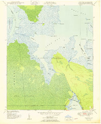
1950 Map of Long Bay
USGS Topo · Published 1950About this map
Hunting Quarters and the low-lying wetlands of Piney Island dominate this coastal survey, where the intricate hydrology of Carteret County is mapped in detail. The landscape is defined by a dense network of tidal guts and creeks, such as Sanborns Gut and Golden Creek, which intersect the expansive salt marshes and forested tracts of Smyrna and the Open Grounds. Navigation is central to the area's character, evidenced by the Old Canal, the Cedar Island Light, and the vital passage of the Thorofare connecting West Thorofare Bay to the Atlantic.
Find a feature on this map
51 named features on this map. Tap any name to fly to it.
Don’t see what you’re looking for? This feature index may not catch every label — zoom into the map to look around manually.
Map Details
Editions of this 1950 Long Bay Map
2 editions found
Other maps of this area

1948 · North Bay
USGS Topo · 1:24,000

1949 · Atlantic
USGS Topo · 1:24,000

1949 · Styron Bay
USGS Topo · 1:24,000

1949 · Point Of Marsh
USGS Topo · 1:24,000

1949 · Long Bay
USGS Topo · 1:24,000

1949 · Williston
USGS Topo · 1:24,000

1949 · South River
USGS Topo · 1:24,000

1949 · Davis
USGS Topo · 1:24,000

1950 · South River
USGS Topo · 1:24,000

1950 · North Bay
USGS Topo · 1:24,000