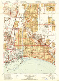
1949 Map of Long Beach
USGS Topo · Published 1952About this map
Signal Hill stands as the topographic and industrial focal point of this coastal landscape, its slopes crowded with Oil Wells and Oil Tanks during a period of intense extraction. The urban expansion of Long Beach and its surrounding neighborhoods like Bixby Knolls and California Heights is evident, showing a dense grid of schools and parks such as Houghton Park and Recreation Park. Along the waterfront, the map documents a sophisticated maritime and recreational infrastructure, featuring the distinctive curve of Rainbow Pier and the Municipal Auditorium alongside the developing industrial harbor. The inland reaches transition from residential tracts to institutional landmarks like the Dominguez Ranch House and Del Amo Jr Seminary, while the Los Angeles River and Dominguez Channel define the drainage patterns of this subsiding coastal plain. This era captures the city's post-war maturity, balancing deep-water commerce at the Turning Basin with burgeoning suburban developments like Lakewood Village.
Find a feature on this map
121 named features on this map. Tap any name to fly to it.
Don’t see what you’re looking for? This feature index may not catch every label — zoom into the map to look around manually.
Map Details
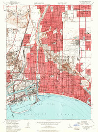
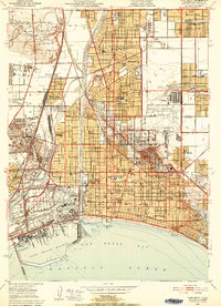
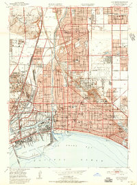
Editions of this 1949 Long Beach Map
4 editions found
Other maps of this area

1896 · Redondo
USGS Topo · 1:62,500

1896 · Las Bolsas
USGS Topo · 1:62,500

1896 · San Pedro
USGS Topo · 1:62,500

1896 · Downey
USGS Topo · 1:62,500

1899 · Downey
USGS Topo · 1:62,500

1901 · Southern California Sheet No. 1
USGS Topo · 1:250,000

1902 · Downey
USGS Topo · 1:62,500

1904 · Southern California Sheet No. 1
USGS Topo · 1:250,000

1923 · Wilmington
USGS Topo · 1:24,000

1924 · Compton
USGS Topo · 1:24,000