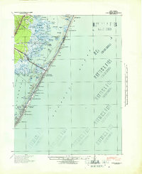
1941 Map of Long Beach
USGS Topo · Published 1941About this map
Barnegat City and the thin, developed stretch of Long Beach Island are seen here in the early 1940s, revealing a landscape defined by seasonal settlements and the Pennsylvania Railroad. The map details the intricate geography of the bay, where features like Double Creek Wide Place and Harvey Sedges break the water between the mainland and the barrier island. Coastal life is centered around established boroughs such as Ship Bottom, Surf City, and the southern hub of Beach Haven.
Find a feature on this map
72 named features on this map. Tap any name to fly to it.
Don’t see what you’re looking for? This feature index may not catch every label — zoom into the map to look around manually.
Map Details
Editions of this 1941 Long Beach Map
This is the sole edition of this map. No revisions or reprints were ever made.
Other maps of this area

1884 · Whitings
USGS Topo · 1:62,500

1887 · Atlantic City
USGS Topo · 1:62,500

1888 · Barnegat
USGS Topo · 1:62,500

1888 · Little Egg Harbor
USGS Topo · 1:62,500

1888 · Long Beach
USGS Topo · 1:62,500

1888 · Whitings
USGS Topo · 1:62,500

1893 · Little Egg Harbor
USGS Topo · 1:62,500

1893 · Long Beach
USGS Topo · 1:62,500

1893 · Barnegat
USGS Topo · 1:62,500

1894 · Atlantic City
USGS Topo · 1:62,500
Featured Places
- Stafford Township, NJ
- Barnegat Township, NJ
- Long Beach Township, NJ
- Eagleswood Township, NJ
- Surf City, NJ