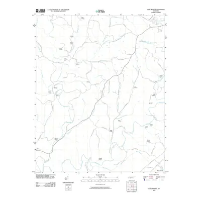
2010 Map of Long Branch
USGS Topo · Published 2010About this map
Shoal Creek and its many winding tributaries, including Knob Creek and Long Branch, define the rural geography of this portion of Tennessee. The landscape is notably marked by an extensive network of family and community burial grounds, such as Mount Zion Cemetery, Ander Smith Cemetery, and Luna Cemetery, which are often located near the junctions of country roads like Waterloo Rd and Rigsby Rd. Local topography is characterized by distinct hollows, including Limekiln Hollow and Drake Hollow, where the terrain dips toward the drainage basins. Small-scale impoundments like Bennett Lake, held by the Bennett Lake Dam, illustrate the local management of water resources in a region primarily defined by its hydrology and the enduring presence of these established family landmarks.
Find a feature on this map
77 named features on this map. Tap any name to fly to it.
Don’t see what you’re looking for? This feature index may not catch every label — zoom into the map to look around manually.
Map Details
Editions of this 2010 Long Branch Map
This is the sole edition of this map. No revisions or reprints were ever made.
Other maps of this area

1905 · Waynesboro
USGS Topo · 1:125,000

1936 · Westpoint
USGS Topo · 1:24,000

1936 · Deerfield
USGS Topo · 1:24,000

1936 · Lawrenceburg
USGS Topo · 1:24,000

1936 · Ethridge
USGS Topo · 1:24,000

1936 · Long Branch
USGS Topo · 1:24,000

1936 · Loretto
USGS Topo · 1:24,000
1936 · St. Joseph
USGS Topo · 1:24,000

1936 · Bonnertown
USGS Topo · 1:24,000

1936 · Ovilla
USGS Topo · 1:24,000