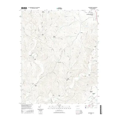
2016 Map of Long Branch
USGS Topo · Published 2016About this map
Shoal Creek and its many winding tributaries define the rolling landscape of southern Lawrence County. Numerous small hollows, such as Limekiln Hollow and Drake Hollow, dictate the placement of rural homesteads and winding roads throughout the region. The map reveals a dense network of family-named cemeteries, including the Mount Lebanon Cem, Kilburn Cem, and Sam Smith Cem, which provide a detailed genealogical record of the families who settled this part of Tennessee. Settlements like Crewstown, Pea Ridge, and Springers Station are connected by a web of local routes like Waterloo Rd and Long Branch Rd. To the northeast, the southern edge of Lawrenceburg shows the transition from rural valley life toward the county's primary urban center, while landmarks like Horseshoe Bend on the creek and Bennett Lake highlight the area's natural drainage patterns.
Find a feature on this map
117 named features on this map. Tap any name to fly to it.
Don’t see what you’re looking for? This feature index may not catch every label — zoom into the map to look around manually.
Map Details
Editions of this 2016 Long Branch Map
This is the sole edition of this map. No revisions or reprints were ever made.
Other maps of this area

1905 · Waynesboro
USGS Topo · 1:125,000

1936 · Westpoint
USGS Topo · 1:24,000

1936 · Deerfield
USGS Topo · 1:24,000

1936 · Lawrenceburg
USGS Topo · 1:24,000

1936 · Ethridge
USGS Topo · 1:24,000

1936 · Long Branch
USGS Topo · 1:24,000

1936 · Loretto
USGS Topo · 1:24,000
1936 · St. Joseph
USGS Topo · 1:24,000

1936 · Bonnertown
USGS Topo · 1:24,000

1936 · Ovilla
USGS Topo · 1:24,000