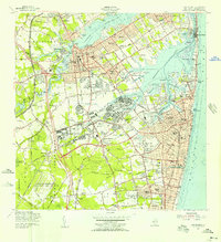
1954 Map of Long Branch
USGS Topo · Published 1956About this map
Fort Monmouth and Camp Charles Wood dominate the central landscape of this mid-century survey, reflecting the area's significance as a military and signals intelligence hub. The coastal corridor between Sea Bright and Monmouth Beach remains a narrow strip of development vulnerable to the Atlantic, while inland, the suburban expansion of Red Bank, Little Silver, and Shrewsbury is clearly underway. The map documents a complex aquatic geography defined by the Navesink River and Shrewsbury River, which carve out numerous points and necks like Gooseneck Point and Horseneck Point.
Find a feature on this map
118 named features on this map. Tap any name to fly to it.
Don’t see what you’re looking for? This feature index may not catch every label — zoom into the map to look around manually.
Map Details
Editions of this 1954 Long Branch Map
5 editions found

Other maps of this area

1888 · Asbury Park
USGS Topo · 1:62,500

1888 · Sandy Hook
USGS Topo · 1:62,500

1893 · Sandy Hook
USGS Topo · 1:62,500

1893 · Asbury Park
USGS Topo · 1:62,500

1901 · Sandy Hook
USGS Topo · 1:62,500

1901 · Asbury Park
USGS Topo · 1:62,500

1902 · Navesink
USGS Topo · 1:125,000

1918 · Sandy Hook
USGS Topo · 1:62,500

1919 · Asbury Park
USGS Topo · 1:62,500

1942 · Farmingdale
USGS Topo · 1:24,000