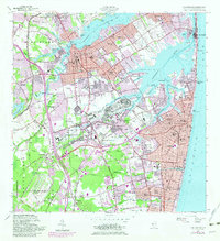
1954 Map of Long Branch
USGS Topo · Published 1982About this map
The Navesink River and Shrewsbury River define the coastal geography of this Monmouth County region, where established boroughs like Red Bank and Little Silver meet the Atlantic shore. This mid-century landscape is heavily influenced by military installations, including the significant footprint of Fort Monmouth and Camp Charles Wood, alongside the U S Naval Weapons Station (Earle) to the southwest. The expansion of urban infrastructure is evident in the purple-shaded revisions from 1976, which highlight the growth around Long Branch and Eatontown. While the coastal strip at Sea Bright remains a narrow barrier between the rivers and the Atlantic Ocean, inland areas show the development of transportation corridors like the Garden State Parkway. Local history is preserved in the numerous cemeteries such as Woodbine Cem and White Ridge Cem, and the specialized institutions like Monmouth Memorial Hospital and Highland Manor School that served these growing coastal communities.
Find a feature on this map
145 named features on this map. Tap any name to fly to it.
Don’t see what you’re looking for? This feature index may not catch every label — zoom into the map to look around manually.
Map Details
Editions of this 1954 Long Branch Map
5 editions found

Other maps of this area

1888 · Asbury Park
USGS Topo · 1:62,500

1888 · Sandy Hook
USGS Topo · 1:62,500

1893 · Sandy Hook
USGS Topo · 1:62,500

1893 · Asbury Park
USGS Topo · 1:62,500

1901 · Sandy Hook
USGS Topo · 1:62,500

1901 · Asbury Park
USGS Topo · 1:62,500

1902 · Navesink
USGS Topo · 1:125,000

1918 · Sandy Hook
USGS Topo · 1:62,500

1919 · Asbury Park
USGS Topo · 1:62,500

1942 · Farmingdale
USGS Topo · 1:24,000