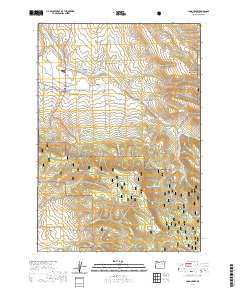
2020 Map of Long Creek
USGS Topo · Published 2020About this map
Long Creek is the central hub of this eastern Oregon landscape, situated at the junction of several critical regional routes including CO Hwy 18 and CO Hwy 12. The settlement is closely tied to its water sources, with the Long Creek Reservoir and the Long Creek Municipal Watershed protected in the hills to the south. Local history is anchored at the Long Creek Cem and marked by geographic points like Coles Bridge to the north.
Find a feature on this map
42 named features on this map. Tap any name to fly to it.
Don’t see what you’re looking for? This feature index may not catch every label — zoom into the map to look around manually.
Map Details
Editions of this 2020 Long Creek Map
This is the sole edition of this map. No revisions or reprints were ever made.
Other maps of this area

1949 · Long Creek
USGS Topo · 1:62,500

1949 · Susanville
USGS Topo · 1:62,500

1950 · Ritter
USGS Topo · 1:62,500

1951 · Susanville
USGS Topo · 1:62,500

1951 · Long Creek
USGS Topo · 1:62,500

1951 · Dale
USGS Topo · 1:62,500

1952 · Ritter
USGS Topo · 1:62,500

1955 · Canyon City
USGS Topo · 1:250,000

1959 · Canyon City
USGS Topo · 1:250,000

1980 · Monument
USGS Topo · 1:100,000