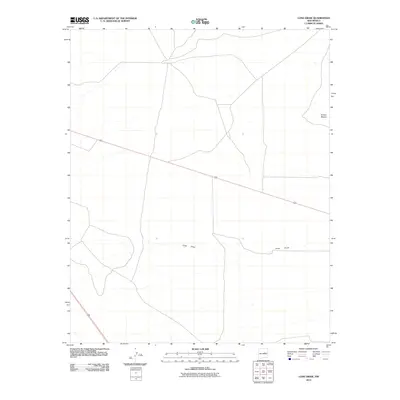
2010 Map of Long Draw
USGS Topo · Published 2010About this map
Long Draw carves a path through this high plains landscape of Guadalupe County, serving as the primary drainage feature for the surrounding terrain. This remote section of New Mexico is defined by its wide-open character and the sparse distribution of named landmarks, with the depression of Sotano Blanco situated in the northeast. The intersection of major transport routes, specifically U.S. Route 60 and U.S. Route 285, dictates the human movement through the quadrangle. These roads follow the natural contours and drainage patterns established by the draw, reflecting a landscape where infrastructure is closely tied to the few defining geographic features. For those studying the connectivity of this region in the early 21st century, the map provides a clear record of the high-desert road network and the subtle elevations that guide the intermittent flow of water across the territory.
Find a feature on this map
4 named features on this map. Tap any name to fly to it.
Don’t see what you’re looking for? This feature index may not catch every label — zoom into the map to look around manually.
Map Details
Editions of this 2010 Long Draw Map
This is the sole edition of this map. No revisions or reprints were ever made.
Other maps of this area

1954 · Fort Sumner
USGS Topo · 1:250,000

1958 · Fort Sumner
USGS Topo · 1:250,000

1978 · Mesa Leon
USGS Topo · 1:24,000

1978 · Vaughn
USGS Topo · 1:24,000

1978 · El Morro Ranch
USGS Topo · 1:24,000

1978 · El Morro Ranch NW
USGS Topo · 1:24,000

1978 · Long Draw
USGS Topo · 1:24,000
1978 · Burro Lake
USGS Topo · 1:24,000

1979 · Fort Sumner
USGS Topo · 1:100,000

1980 · Corona
USGS Topo · 1:100,000