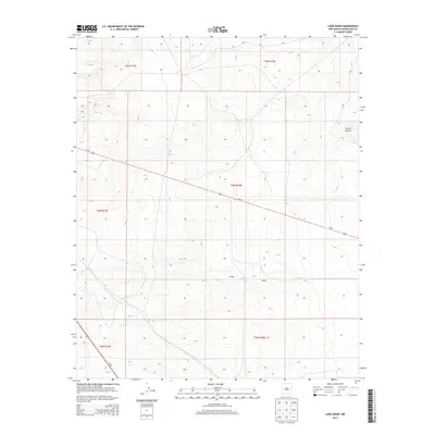
2013 Map of Long Draw
USGS Topo · Published 2013About this map
Long Draw and the surrounding high plains of Guadalupe County are defined by a sparse, rhythmic landscape of section lines and intermittent drainages. This 2013 survey by the U.S. Geological Survey illustrates a region of New Mexico dominated by vast ranching tracts and minimal modern development. The primary topographic interruption in this high-elevation terrain is the natural depression of Long Draw, which meanders through the southern half of the quadrangle. Transportation is anchored by two major regional thoroughfares: Us-60 crosses the center of the map from west to east, while Us-285 cuts through the southwestern corner. Near the northeastern boundary, the named terrain of Sotano Blanco provides a specific point of reference in an area otherwise characterized by its wide-open character and the orderly grid of the Public Land Survey System.
Find a feature on this map
12 named features on this map. Tap any name to fly to it.
Don’t see what you’re looking for? This feature index may not catch every label — zoom into the map to look around manually.
Map Details
Editions of this 2013 Long Draw Map
This is the sole edition of this map. No revisions or reprints were ever made.
Other maps of this area

1954 · Fort Sumner
USGS Topo · 1:250,000

1958 · Fort Sumner
USGS Topo · 1:250,000

1978 · Mesa Leon
USGS Topo · 1:24,000

1978 · Vaughn
USGS Topo · 1:24,000

1978 · El Morro Ranch
USGS Topo · 1:24,000

1978 · El Morro Ranch NW
USGS Topo · 1:24,000

1978 · Long Draw
USGS Topo · 1:24,000
1978 · Burro Lake
USGS Topo · 1:24,000

1979 · Fort Sumner
USGS Topo · 1:100,000

1980 · Corona
USGS Topo · 1:100,000