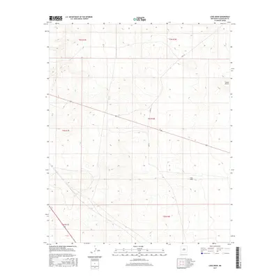
2017 Map of Long Draw
USGS Topo · Published 2017About this map
Long Draw carves a path through this high plains landscape of Guadalupe County, serving as the central topographic feature of the quadrangle. The terrain is defined by the subtle drainage patterns typical of the New Mexico interior, including the localized depression or landmark at Sotano Blanco in the northeastern reaches. Modern accessibility is limited to a few named rural routes, specifically Perez Rd and Eden Rd, which navigate the township and range boundaries. This late-2010s survey by the U.S. Geological Survey illustrates the enduring grid of the Public Land Survey System, showing sections within T4N R18E and surrounding townships. The landscape remains largely open, with contour intervals revealing the gradual elevations that characterize the approach to the Pecos River valley further west.
Find a feature on this map
10 named features on this map. Tap any name to fly to it.
Don’t see what you’re looking for? This feature index may not catch every label — zoom into the map to look around manually.
Map Details
Editions of this 2017 Long Draw Map
This is the sole edition of this map. No revisions or reprints were ever made.
Other maps of this area

1954 · Fort Sumner
USGS Topo · 1:250,000

1958 · Fort Sumner
USGS Topo · 1:250,000

1978 · Mesa Leon
USGS Topo · 1:24,000

1978 · Vaughn
USGS Topo · 1:24,000

1978 · El Morro Ranch
USGS Topo · 1:24,000

1978 · El Morro Ranch NW
USGS Topo · 1:24,000

1978 · Long Draw
USGS Topo · 1:24,000
1978 · Burro Lake
USGS Topo · 1:24,000

1979 · Fort Sumner
USGS Topo · 1:100,000

1980 · Corona
USGS Topo · 1:100,000