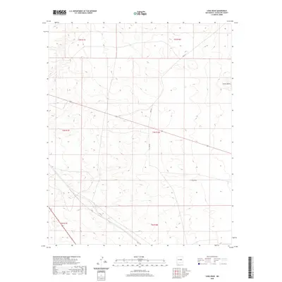
2020 Map of Long Draw
USGS Topo · Published 2020About this map
Long Draw winds through this expanse of Guadalupe County, serving as the central geographic feature of a landscape defined by its rural road network and section lines. The settlement of Sotano Blanco sits on the eastern edge of the quadrangle, connected to the surrounding ranch land by gravel routes such as Perez Rd and Eden Rd. These thoroughfares, along with Rica Rd in the southwest, illustrate the traditional land use patterns of east-central New Mexico. The map provides a precise layout of the Public Land Survey System, showing the townships and ranges that have governed property boundaries in this high-plains environment since the late nineteenth century.
Find a feature on this map
11 named features on this map. Tap any name to fly to it.
Don’t see what you’re looking for? This feature index may not catch every label — zoom into the map to look around manually.
Map Details
Editions of this 2020 Long Draw Map
This is the sole edition of this map. No revisions or reprints were ever made.
Other maps of this area

1954 · Fort Sumner
USGS Topo · 1:250,000

1958 · Fort Sumner
USGS Topo · 1:250,000

1978 · Mesa Leon
USGS Topo · 1:24,000

1978 · Vaughn
USGS Topo · 1:24,000

1978 · El Morro Ranch
USGS Topo · 1:24,000

1978 · El Morro Ranch NW
USGS Topo · 1:24,000

1978 · Long Draw
USGS Topo · 1:24,000
1978 · Burro Lake
USGS Topo · 1:24,000

1979 · Fort Sumner
USGS Topo · 1:100,000

1980 · Corona
USGS Topo · 1:100,000