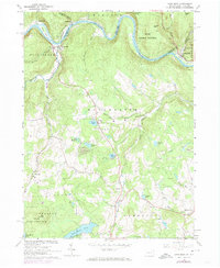
1965 Map of Long Eddy
USGS Topo · Published 1974About this map
The Delaware River carves a deep valley along the border of Wayne County, Pennsylvania, and Delaware County, New York, serving as the primary corridor for both the Erie-Lackawanna railroad and the riverfront hamlets of Equinunk and Lordville. This 1965 survey, updated with 1973 revisions, reveals an upland landscape defined by small-scale resource extraction and seasonal recreation. Numerous Quarries dot the hillsides near Long Eddy, while the interior of Manchester and Damascus townships is characterized by a network of summer camps, including Camp Equinunk, Camp Blue Ridge, and Camp Choppee. Local history is preserved in the scattered rural hubs such as Priceville, Braman, and Abrahamsville, alongside the Union Ch and various family-named water bodies like Margaret Lake and Peterson Lake. The southern portion of the map transitions into the Lebanon State Game Lands No 159, showing a shift from the agrarian and industrial riverfront toward protected wilderness near Duck Harbor Pond.
Find a feature on this map
58 named features on this map. Tap any name to fly to it.
Don’t see what you’re looking for? This feature index may not catch every label — zoom into the map to look around manually.
Map Details
Editions of this 1965 Long Eddy Map
3 editions found
Other maps of this area

1892 · Honesdale
USGS Topo · 1:62,500

1920 · Long Eddy
USGS Topo · 1:62,500

1920 · Damascus
USGS Topo · 1:62,500

1921 · Long Eddy
USGS Topo · 1:48,000

1923 · Damascus
USGS Topo · 1:62,500

1923 · Long Eddy
USGS Topo · 1:62,500

1924 · Starrucca
USGS Topo · 1:48,000

1926 · Starrucca
USGS Topo · 1:62,500

1930 · Starrucca
USGS Topo · 1:48,000

1933 · Starrucca
USGS Topo · 1:62,500