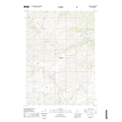
2020 Map of Long Gulch
USGS Topo · Published 2020About this map
Boise National Forest land dominates this section of Elmore County, where the South Fork Boise River cuts through the southwestern corner of the sheet. The landscape is defined by its drainage systems and sharp ridges, notably Rattlesnake Ridge and heights like Grape Mountain and Krall Mtn. Evidence of forest management and access is clear through the extensive network of numbered forest roads and trails, including Rattlesnake Loop and Grape Mtn Trail A. Small settlements and named locales like Long Gulch and Lower Bench are situated near the waterways. The southern portion of the map transitions toward the open area of Smith Prairie, while numerous seasonal and perennial streams such as Blacks Creek and Little Rattlesnake Cr create a complex network of canyons and gulches including the prominent Slide Gulch.
Find a feature on this map
60 named features on this map. Tap any name to fly to it.
Don’t see what you’re looking for? This feature index may not catch every label — zoom into the map to look around manually.
Map Details
Editions of this 2020 Long Gulch Map
This is the sole edition of this map. No revisions or reprints were ever made.
Other maps of this area

1892 · Mountain Home
USGS Topo · 1:125,000

1893 · Mountain Home
USGS Topo · 1:125,000

1894 · Idaho Basin
USGS Topo · 1:125,000

1955 · Hailey
USGS Topo · 1:250,000

1959 · Hailey
USGS Topo · 1:250,000

1960 · Mayfield
USGS Topo · 1:62,500

1960 · Danskin Peak
USGS Topo · 1:62,500

1962 · Hailey
USGS Topo · 1:250,000
1964 · Prairie
USGS Topo · 1:24,000

1964 · Sheep Creek
USGS Topo · 1:24,000