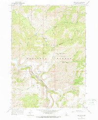
1964 Map of Long Gulch
USGS Topo · Published 1966About this map
The South Fork Boise River cuts a deep path through this section of the Boise National Forest in Elmore County, defining a landscape shaped by narrow canyons and high ridges. Significant elevation is reached at Krall Mountain, while the hydrology of the area is dominated by numerous drainages such as Elk Creek, Rattlesnake Creek, and Long Gulch. Human presence in the mid-1960s was centered on forest management and recreation, evidenced by the Long Gulch Guard Station and Rattlesnake Campground. A network of primitive transport, labeled simply as Jeep Trail, provides the primary access into the steep backcountry. This survey records the drainage patterns and creek systems, including Timber Creek and Fiddler Creek, before modern infrastructure further altered the wilderness character of the region.
Find a feature on this map
27 named features on this map. Tap any name to fly to it.
Don’t see what you’re looking for? This feature index may not catch every label — zoom into the map to look around manually.
Map Details
Editions of this 1964 Long Gulch Map
This is the sole edition of this map. No revisions or reprints were ever made.
Other maps of this area

1892 · Mountain Home
USGS Topo · 1:125,000

1893 · Mountain Home
USGS Topo · 1:125,000

1894 · Idaho Basin
USGS Topo · 1:125,000

1955 · Hailey
USGS Topo · 1:250,000

1959 · Hailey
USGS Topo · 1:250,000

1960 · Mayfield
USGS Topo · 1:62,500

1960 · Danskin Peak
USGS Topo · 1:62,500

1962 · Hailey
USGS Topo · 1:250,000
1964 · Prairie
USGS Topo · 1:24,000

1964 · Sheep Creek
USGS Topo · 1:24,000